
Make a donation
Independencia topographic map
Click on the map to display elevation.
Make a donation
About this map
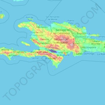
Name: Independencia topographic map, elevation, terrain.
Location: Independencia, Dominican Republic (15.78395 -74.23859 20.98395 -69.03859)
Average elevation: 90 m
Minimum elevation: -44 m
Maximum elevation: 2,929 m
Make a donation
Other topographic maps
Click on a map to view its topography, its elevation and its terrain.
Río Isabela
Dominican Republic > Santo Domingo > Santo Domingo Norte > Villa Mella
Average elevation: 32 m
Constanza
The town of Constanza is located at a height of 1220 meters (4000 ft) above sea level in the middle of the Cordillera Central (Central Range), the tallest mountain range in the island of Hispaniola and the entire Caribbean region. The annual average temperatures range from 41 °F (5 °C) to 68 °F (20 °C),…
Average elevation: 1,473 m
Make a donation
San Francisco de Macorís
The relief of Duarte Province ranges from 17 to 942 metres (56 to 3,091 ft) above sea level, reaching its highest elevation at "Loma Quita Espuela". This name allegedly comes from the time when the Spaniards were exploring the island, since the hill was too steep to ride their horses, they had to dismount and…
Average elevation: 218 m
Make a donation
Make a donation
Santiago de los Caballeros
Santiago de los Caballeros (Spanish pronunciation: [sanˈtjaɣo ðe los kaβaˈʝeɾos]; English: Saint James of the Knights), often shortened to Santiago, is the second-largest city in the Dominican Republic and the fourth-largest city in the Caribbean by population. It is the capital of Santiago Province and…
Average elevation: 341 m
Moca
Dominican Republic > Espaillat
Moca has a total area of 339.21 km². The municipality sits on a volcanic coral reef with hills to the west and low mountains to the north; these mountains are part of the Cordillera Septentrional. The highest mountain in the municipality, and in the province, is El Mogote at (970 m). Moca is at an elevation…
Average elevation: 365 m
Make a donation
Make a donation