
Thank you for supporting this site ❤️
Make a donation
Make a donation
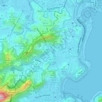
Santa Teresa topographic map
Click on the map to display elevation.
Thank you for supporting this site ❤️
Make a donation
Make a donation
Santa Teresa
Around 1850 many people, fleeing the yellow fever epidemic in the city, flocked to the neighborhood. As it was at a higher altitude, Santa Teresa was less affected by the epidemic than the surrounding neighborhoods.
Thank you for supporting this site ❤️
Make a donation
Make a donation
About this map
Name: Santa Teresa topographic map, elevation, terrain.
Location: Santa Teresa, Rio de Janeiro, Southeast Region, Brazil (-22.95229 -43.21911 -22.91140 -43.17712)
Average elevation: 55 m
Minimum elevation: -2 m
Maximum elevation: 530 m
Thank you for supporting this site ❤️
Make a donation
Make a donation