
Thank you for supporting this site ❤️
Make a donation
Make a donation
Guaíba topographic map
Click on the map to display elevation.
Thank you for supporting this site ❤️
Make a donation
Make a donation
About this map
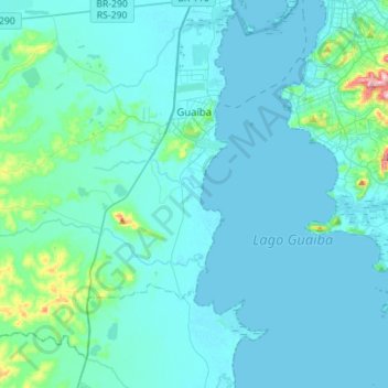
Name: Guaíba topographic map, elevation, terrain.
Average elevation: 22 m
Minimum elevation: -1 m
Maximum elevation: 264 m
Thank you for supporting this site ❤️
Make a donation
Make a donation
Other topographic maps
Click on a map to view its topography, its elevation and its terrain.
Quarto Frio
Brazil > Rio Grande do Sul > Metropolitan Region of Porto Alegre > Taquara
Average elevation: 264 m
Praça
Brazil > Rio Grande do Sul > Metropolitan Region of Porto Alegre > Porto Alegre
Average elevation: 15 m