
Thank you for supporting this site ❤️
Make a donation
Make a donation
Łysa Polana topographic map
Click on the map to display elevation.
Thank you for supporting this site ❤️
Make a donation
Make a donation
About this map
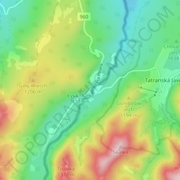
Name: Łysa Polana topographic map, elevation, terrain.
Average elevation: 1,093 m
Minimum elevation: 906 m
Maximum elevation: 1,423 m
Thank you for supporting this site ❤️
Make a donation
Make a donation
Other topographic maps
Click on a map to view its topography, its elevation and its terrain.
Czarny Staw Polski
Poland > Lesser Poland Voivodeship > Tatra County > Brzegi
Average elevation: 1,810 m
Morskie Oko
Poland > Lesser Poland Voivodeship > Tatra County > Brzegi
Morskie Oko at the foothill of Tatra Mountains in southern Poland which average 2,000 metres (6,600 ft) in elevation
Average elevation: 1,749 m