
Thank you for supporting this site ❤️
Make a donation
Make a donation
Chãs d'Égua topographic map
Click on the map to display elevation.
Thank you for supporting this site ❤️
Make a donation
Make a donation
About this map
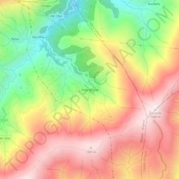
Name: Chãs d'Égua topographic map, elevation, terrain.
Location: Chãs d'Égua, Piódão, Arganil, Coimbra, 3305-242, Portugal (40.21630 -7.81910 40.25630 -7.77910)
Average elevation: 896 m
Minimum elevation: 412 m
Maximum elevation: 1,332 m
Thank you for supporting this site ❤️
Make a donation
Make a donation
Other topographic maps
Click on a map to view its topography, its elevation and its terrain.