
Make a donation
County Dublin topographic map
Click on the map to display elevation.
Make a donation
County Dublin
Dublin is a topographically varied region. The city centre is generally very low-lying, and many areas of coastal Dublin are at or near sea-level. In the south of the county, the topography rises steeply from sea-level at the coast to over 500 metres (1,600 ft) in just a few kilometres. This natural barrier has resulted in densely populated coastal settlements in Dún Laoghaire–Rathdown and westward urban sprawl in South Dublin. In contrast, Fingal is generally rural in nature and much less densely populated than the rest of the county. Consequently, Fingal is significantly larger than the other three local authorities and covers about 49.5% of County Dublin's land area. Fingal is also perhaps the flattest region in Ireland, with the low-lying Naul Hills rising to a maximum height of just 176 metres (577 ft).
Make a donation
About this map
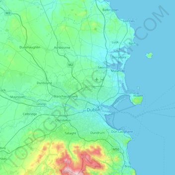
Name: County Dublin topographic map, elevation, terrain.
Location: County Dublin, Leinster, Ireland (53.17826 -6.54689 53.63473 -5.99450)
Average elevation: 71 m
Minimum elevation: -1 m
Maximum elevation: 733 m
Make a donation
Other topographic maps
Click on a map to view its topography, its elevation and its terrain.
Make a donation
Make a donation
Make a donation
Bruree
Ireland > County Limerick > The Municipal District of Cappamore — Kilmallock
Average elevation: 62 m
Make a donation
Watergrasshill
According to A Topographical Dictionary of Ireland, published by Samuel Lewis in 1837, Watergrasshill then had a population of 533 people.
Average elevation: 164 m
Tory Hill
Ireland > County Limerick > The Municipal District of Adare — Rathkeale
Average elevation: 35 m
Make a donation
Make a donation
Make a donation
Make a donation
Make a donation
Make a donation
Make a donation
Blanchardstown
Blanchardstown was a predominantly rural area, with a small village, in western County Dublin, alongside the neighbouring district of Castleknock. Both areas shared a common history until well into the 19th century, when their development diverged. In A Topographical Dictionary of Ireland, published in 1837,…
Average elevation: 61 m
Make a donation
Make a donation
Aherlow
Ireland > County Limerick > The Municipal District of Cappamore — Kilmallock
Average elevation: 141 m
Make a donation
Make a donation
Galtymore
Ireland > County Limerick > The Municipal District of Cappamore — Kilmallock
Galtymore or Galteemore (Irish: Cnoc Mór na nGaibhlte, meaning 'big hill of the Galtees') is a mountain in the province of Munster, Ireland. At 917.9 metres (3,011 ft 6 in), it is one of Ireland's highest mountains, being the 12th-highest on the Arderin list, and 14th-highest on the Vandeleur-Lynam list.…
Average elevation: 594 m
Make a donation
Make a donation
Make a donation
Make a donation
Make a donation
Brandon Hill
Brandon Hill (Irish: Cnoc Bhréanail) is the highest mountain in County Kilkenny, Ireland, with an elevation of 515 m (1,690 ft) and prominence at 448 m (1,470 ft). The South Leinster Way, a long-distance trail, meandering through the Barrow Valley and traverses Brandon Hill. The village of Graiguenamanagh and…
Average elevation: 294 m
Make a donation
Make a donation
Make a donation
Make a donation
Make a donation