
Kerguelen Archipelago topographic map
Interactive map
Click on the map to display elevation.
About this map
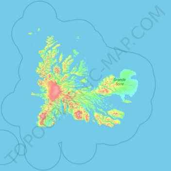
Name: Kerguelen Archipelago topographic map, elevation, terrain.
Average elevation: 39 m
Minimum elevation: -2 m
Maximum elevation: 1,582 m
Other topographic maps
Click on a map to view its topography, its elevation and its terrain.
La Grande Bastide
France, Terres australes et antarctiques françaises, Îles Kerguelen (eaux territoriales) > French Southern and Antarctic Lands
La Grande Bastide, Kerguelen Archipelago, French Southern and Antarctic Lands, France, Terres australes et antarctiques françaises, Îles Kerguelen (eaux territoriales)
Average elevation: 66 m
Glacier Cook
France, Terres australes et antarctiques françaises, Îles Kerguelen (eaux territoriales)
Glacier Cook, Kerguelen Archipelago, France, Terres australes et antarctiques françaises, Îles Kerguelen (eaux territoriales)
Average elevation: 508 m