
Thank you for supporting this site ❤️
Make a donation
Make a donation
Donville-les-Bains topographic map
Click on the map to display elevation.
Thank you for supporting this site ❤️
Make a donation
Make a donation
About this map
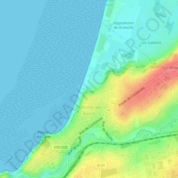
Name: Donville-les-Bains topographic map, elevation, terrain.
Average elevation: 17 m
Minimum elevation: 0 m
Maximum elevation: 68 m
Thank you for supporting this site ❤️
Make a donation
Make a donation
Other topographic maps
Click on a map to view its topography, its elevation and its terrain.
Thank you for supporting this site ❤️
Make a donation
Make a donation
Thank you for supporting this site ❤️
Make a donation
Make a donation
Hameau Val Fontaine
France > Normandy > Manche > Bricquebec-en-Cotentin > Les Perques
Average elevation: 66 m
Thank you for supporting this site ❤️
Make a donation
Make a donation
Thank you for supporting this site ❤️
Make a donation
Make a donation