
Thank you for supporting this site ❤️
Make a donation
Make a donation
Ściechów topographic map
Click on the map to display elevation.
Thank you for supporting this site ❤️
Make a donation
Make a donation
About this map
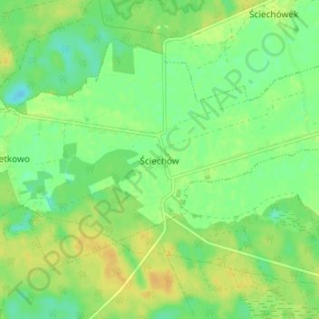
Name: Ściechów topographic map, elevation, terrain.
Average elevation: 57 m
Minimum elevation: 45 m
Maximum elevation: 68 m
Thank you for supporting this site ❤️
Make a donation
Make a donation
Other topographic maps
Click on a map to view its topography, its elevation and its terrain.
Kostrzyn nad Odrą
Poland > Lubusz Voivodeship > Gorzów County > Kostrzyn upon Oder
Average elevation: 29 m
Thank you for supporting this site ❤️
Make a donation
Make a donation