
Thank you for supporting this site ❤️
Make a donation
Make a donation
Svinø topographic map
Click on the map to display elevation.
Thank you for supporting this site ❤️
Make a donation
Make a donation
About this map
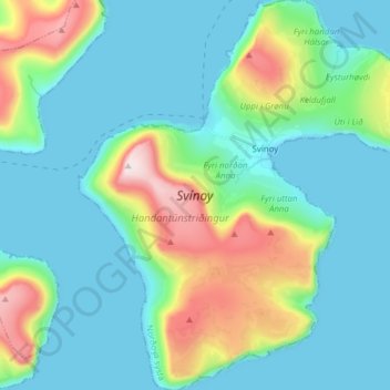
Name: Svinø topographic map, elevation, terrain.
Location: Svinø, Klaksvíkar kommuna, Norderøerne syssel, 765, Færøerne (62.23342 -6.41653 62.30536 -6.28378)
Average elevation: 129 m
Minimum elevation: -6 m
Maximum elevation: 584 m
Thank you for supporting this site ❤️
Make a donation
Make a donation