
Thank you for supporting this site ❤️
Make a donation
Make a donation
Sesimbra topographic map
Click on the map to display elevation.
Thank you for supporting this site ❤️
Make a donation
Make a donation
About this map
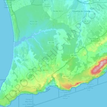
Name: Sesimbra topographic map, elevation, terrain.
Location: Sesimbra, Setúbal, Portugal (38.40907 -9.22292 38.58332 -9.01765)
Average elevation: 69 m
Minimum elevation: -3 m
Maximum elevation: 487 m
Thank you for supporting this site ❤️
Make a donation
Make a donation
Other topographic maps
Click on a map to view its topography, its elevation and its terrain.