
Thank you for supporting this site ❤️
Make a donation
Make a donation
Sahuayo topographic map
Click on the map to display elevation.
Thank you for supporting this site ❤️
Make a donation
Make a donation
About this map
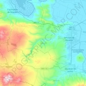
Name: Sahuayo topographic map, elevation, terrain.
Location: Sahuayo, Michoacán, 59103, Mexico (20.00240 -102.86485 20.09355 -102.66770)
Average elevation: 1,796 m
Minimum elevation: 1,517 m
Maximum elevation: 2,567 m
Thank you for supporting this site ❤️
Make a donation
Make a donation
Other topographic maps
Click on a map to view its topography, its elevation and its terrain.
Thank you for supporting this site ❤️
Make a donation
Make a donation
Ihuatzio
Mexico > Michoacán > Tzintzuntzan
Ihuatzio is located on the southeast of the Lake Pátzcuaro, about 8 kilometers southwest of the town center of Tzintzuntzan. Its average elevation is 2,052 meters above the sea level.
Average elevation: 2,052 m
Thank you for supporting this site ❤️
Make a donation
Make a donation