
Thank you for supporting this site ❤️
Make a donation
Make a donation
Cachopo topographic map
Click on the map to display elevation.
Thank you for supporting this site ❤️
Make a donation
Make a donation
About this map
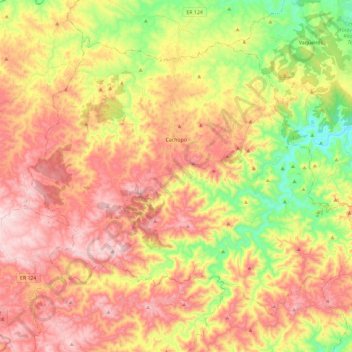
Name: Cachopo topographic map, elevation, terrain.
Location: Cachopo, Tavira, Faro, Portugal (37.24019 -7.91518 37.38697 -7.68226)
Average elevation: 344 m
Minimum elevation: 107 m
Maximum elevation: 550 m
Thank you for supporting this site ❤️
Make a donation
Make a donation
Other topographic maps
Click on a map to view its topography, its elevation and its terrain.