
Thank you for supporting this site ❤️
Make a donation
Make a donation
Funtensee topographic map
Click on the map to display elevation.
Thank you for supporting this site ❤️
Make a donation
Make a donation
Funtensee
The lake lies at an elevation of 1601 m and has a surface area is 3.5 ha. Its outflow toward the Schrainbach is subterranean at a location called Teufelsmühle. On its shore is the Kärlinger Haus mountain hut which is open for the summer season; in addition, there is a winter room available. The valley is surrounded by the mountains Viehkogel (2,158 m), Glunkerer (1,932 m) and Stuhljoch (2,448 m) which lead to the Funtenseetauern mountain (2,578 m), named after the lake.
Thank you for supporting this site ❤️
Make a donation
Make a donation
About this map
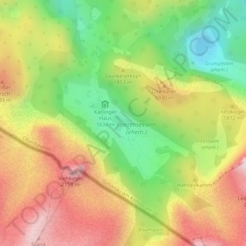
Name: Funtensee topographic map, elevation, terrain.
Average elevation: 1,813 m
Minimum elevation: 1,470 m
Maximum elevation: 2,171 m
Thank you for supporting this site ❤️
Make a donation
Make a donation