
Thank you for supporting this site ❤️
Make a donation
Make a donation
Buhl-Lorraine topographic map
Click on the map to display elevation.
Thank you for supporting this site ❤️
Make a donation
Make a donation
Buhl-Lorraine
Buhl-Lorraine is located 3 miles from Sarrebourg. Its elevation is about 260 meters.
Thank you for supporting this site ❤️
Make a donation
Make a donation
About this map
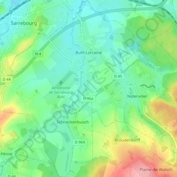
Name: Buhl-Lorraine topographic map, elevation, terrain.
Average elevation: 279 m
Minimum elevation: 244 m
Maximum elevation: 358 m
Thank you for supporting this site ❤️
Make a donation
Make a donation
Other topographic maps
Click on a map to view its topography, its elevation and its terrain.