
Thank you for supporting this site ❤️
Make a donation
Make a donation
Harz (LK Goslar) topographic map
Click on the map to display elevation.
Thank you for supporting this site ❤️
Make a donation
Make a donation
About this map
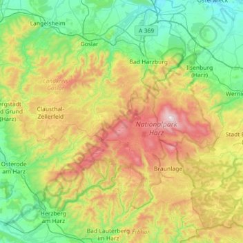
Name: Harz (LK Goslar) topographic map, elevation, terrain.
Location: Harz (LK Goslar), Landkreis Goslar, Lower Saxony, Germany (51.63808 10.13715 51.95001 10.70165)
Average elevation: 444 m
Minimum elevation: 120 m
Maximum elevation: 1,142 m
Thank you for supporting this site ❤️
Make a donation
Make a donation
Other topographic maps
Click on a map to view its topography, its elevation and its terrain.