
Make a donation
Maluku topographic map
Click on the map to display elevation.
Make a donation
Maluku
The topography of the average condition of the Ambon region is rather flat, starting from the coast to residential areas. The mainland morphology of Ambon also varies from flat, bumpy, bumpy, hilly and mountainous with soft steep slopes to slightly dominant. The flat area has a slope of 0–3%, corrugated slope 3–8%, corrugated area 8–15%, hilly area 15–30% slope elevation and mountainous area greater than 30%. As for the Central Maluku Regency, West Seram and East Seram, the topography is generally hilly. 0–2%, tilt / wavy 3–15% rather steep 15–40% and very steep 40%.
Make a donation
About this map
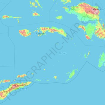
Name: Maluku topographic map, elevation, terrain.
Location: Maluku, Indonesia (-8.55226 124.95184 -2.26642 135.58989)
Average elevation: 45 m
Minimum elevation: -3 m
Maximum elevation: 2,811 m
Make a donation
Other topographic maps
Click on a map to view its topography, its elevation and its terrain.
Make a donation
Make a donation
Make a donation
Alun-Alun Ambarawa
Indonesia > Central Java > Kabupaten Semarang > Tambakboyo > Katang
Average elevation: 499 m
Make a donation
Make a donation
Make a donation
Make a donation
Make a donation
Make a donation
Make a donation
Make a donation
Make a donation
Make a donation
Make a donation
Make a donation
Make a donation
Make a donation
Mount Galunggung
One plane—British Airways Flight 009, carrying 248 passengers and 15 crew traveling from Kuala Lumpur, Malaysia, to Perth, Australia, on June 24, 1982—accidentally entered the ash cloud at night, about 150 km (93 mi; 81 nmi) downwind of the volcano. All four engines failed due to the build-up of volcanic…
Average elevation: 1,286 m
Make a donation
Make a donation
Make a donation
Make a donation
Make a donation
Make a donation
Make a donation
Make a donation