
Cantón Pérez Zeledón topographic map
Interactive map
Click on the map to display elevation.
About this map
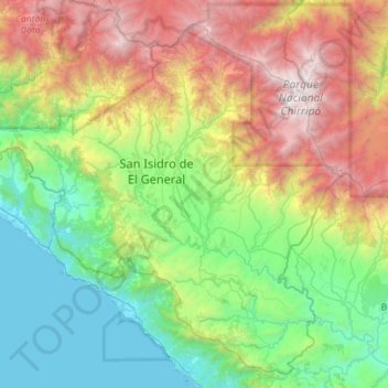
Name: Cantón Pérez Zeledón topographic map, elevation, terrain.
Location: Cantón Pérez Zeledón, Provincia San José, Costa Rica (9.07996 -84.00534 9.59845 -83.42514)
Average elevation: 1,213 m
Minimum elevation: -1 m
Maximum elevation: 3,780 m
Other topographic maps
Click on a map to view its topography, its elevation and its terrain.
Catedral
Costa Rica > Provincia San José > Catedral
Catedral, Cantón San José, Provincia San José, 10104, Costa Rica
Average elevation: 1,155 m