
Thank you for supporting this site ❤️
Make a donation
Make a donation
Los Santos topographic map
Click on the map to display elevation.
Thank you for supporting this site ❤️
Make a donation
Make a donation
About this map
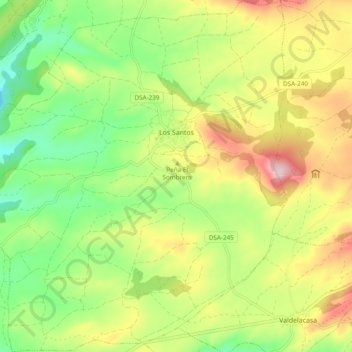
Name: Los Santos topographic map, elevation, terrain.
Location: Los Santos, Salamanca, Castile and León, Spain (40.49930 -5.85604 40.57235 -5.76700)
Average elevation: 936 m
Minimum elevation: 813 m
Maximum elevation: 1,102 m
Thank you for supporting this site ❤️
Make a donation
Make a donation
Other topographic maps
Click on a map to view its topography, its elevation and its terrain.