
Thank you for supporting this site ❤️
Make a donation
Make a donation
Ash Sheikh Zayed topographic map
Click on the map to display elevation.
Thank you for supporting this site ❤️
Make a donation
Make a donation
About this map
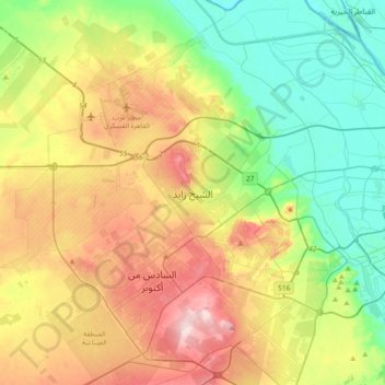
Name: Ash Sheikh Zayed topographic map, elevation, terrain.
Location: Ash Sheikh Zayed, Giza, 12588, Egypt (29.88533 30.81975 30.20533 31.13975)
Average elevation: 105 m
Minimum elevation: 5 m
Maximum elevation: 264 m
Thank you for supporting this site ❤️
Make a donation
Make a donation
Other topographic maps
Click on a map to view its topography, its elevation and its terrain.
Thank you for supporting this site ❤️
Make a donation
Make a donation
Thank you for supporting this site ❤️
Make a donation
Make a donation
Thank you for supporting this site ❤️
Make a donation
Make a donation
Thank you for supporting this site ❤️
Make a donation
Make a donation