
Thank you for supporting this site ❤️
Make a donation
Make a donation
Idlib Governorate topographic map
Click on the map to display elevation.
Thank you for supporting this site ❤️
Make a donation
Make a donation
About this map
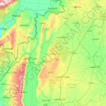
Name: Idlib Governorate topographic map, elevation, terrain.
Location: Idlib Governorate, Syria (35.37675 36.14861 36.34289 37.21628)
Average elevation: 400 m
Minimum elevation: 0 m
Maximum elevation: 1,771 m
Thank you for supporting this site ❤️
Make a donation
Make a donation
Other topographic maps
Click on a map to view its topography, its elevation and its terrain.
An Nabk
Syria > Rif Dimashq Governorate
An-Nabek or Al-Nabek (Arabic: ٱلنَّبْك, romanized: an-Nabk) is a Syrian city administratively belonging to Rif Dimashq and the capital of the Qalamoun. Located 81 kilometers (50 mi) north of Damascus and south of Homs. It has an altitude of 1255 meters. According to the Syria Central Bureau of…
Average elevation: 1,304 m
Thank you for supporting this site ❤️
Make a donation
Make a donation