
Make a donation
Şahdağ topographic map
Click on the map to display elevation.
Make a donation
About this map
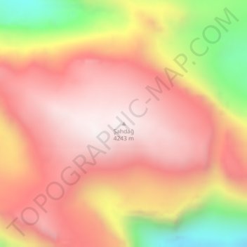
Name: Şahdağ topographic map, elevation, terrain.
Location: Şahdağ, Qusar District, Azerbaijan (41.27062 48.00967 41.27072 48.00977)
Average elevation: 3,860 m
Minimum elevation: 3,155 m
Maximum elevation: 4,253 m
Make a donation
Other topographic maps
Click on a map to view its topography, its elevation and its terrain.
Make a donation
Make a donation
Make a donation
Jalilabad District
The territory of the district primarily consists of plains and low mountains. The elevation of the eastern part is below sea level. The climate is mild with dry summers. The average temperature is 1–3 °C (34–37 °F) in winter and 25–30 °C (77–86 °F) in summer. The average amount of annual…
Average elevation: 185 m
Make a donation
Make a donation
Make a donation
Make a donation
Make a donation
Naftalan City
Naftalan city is located 330 km west of Baku, 50 km from Ganja in the foothills of the Lesser Caucasus Mountains. It's located at an altitude of 225 m above sea level. The spring is warm, the winter is soft here. The average annual temperature is +14.8 degrees. The wind in Naftalan is mainly monsoon. The…
Average elevation: 242 m
Make a donation
Gazakh
Gazakh region is located in the western part of the republic, in the western part of the vast Ganja-Gazakh plain, which starts from the slopes of the mountain range of the Lesser Caucasus and extends along the right bank of the Kura river. The highest elevation is "Odun" mountain (1316 meters). Its nature is…
Average elevation: 376 m
Make a donation
Beylagan District
Beylagan is one of the southwestern districts of Azerbaijan and situated in the Mil valley of the Kur – Araz lowland and in the middle of the Kur and Araz rivers. Geographical coordinates are 39°45’ North latitude and 47°30’ West longitude and bordering Agchabadi, Zardab, Imishli, Fuzuli districts and…
Average elevation: 58 m
Make a donation
Make a donation
Make a donation
Neftchala
Throughout its history, Neftçala has suffered from floods because of its proximity to the river and most of the town's relatively low elevation.
Average elevation: -27 m
Make a donation
Mingachevir Reservoir
Vagif Dargahli, spokesperson of Azerbaijan's Ministry of Defense stated in July 2020 that the "land topography of the Mingachevir water reservoir, protective land works in the area and advanced air defense systems in service with the country’s missile defense troops make a strike on this strategically…
Average elevation: 174 m
Make a donation
Khyrdalan
Khyrdalan is located in the western part of the Absheron Peninsula, south of the Jeyranbatan Reservoir, between Baku and Sumgait, at an elevation of 71 meters above sea level. It lies just 5 kilometers from Baku and is situated in a seismically active region, with an earthquake intensity of 8 points on the…
Average elevation: 79 m
Make a donation
Make a donation
Make a donation
Gadabay
Gadabay lies at the northern foot of the Shahdagh Range, at an altitude of 1460 meters, on the coast of the Mis River. The city is located in the middle and high mountainous areas of the Lesser Caucasus (also called Little Caucasus).
Average elevation: 1,504 m
Make a donation
Make a donation
Make a donation
Shabran District
The greater part of the district is mountainous. The Caspian Sea is located 12 km from Shabran city. The district borders upon Quba, Khachmaz, Shamakhi and Siazan Districts. Forests occupy 27000 ha in mountainous territories and plains near the Caspian Sea and they are of great importance with their climatic…
Average elevation: 523 m
Make a donation
Guba
Quba (Guba) is a city and the administrative centre of the Quba District of Azerbaijan. The city lies on the north-eastern slopes of Shahdag mountain, at an altitude of 600 metres above sea level, on the right bank of the Kudyal river. It has a population of 47,200 (2023).
Average elevation: 623 m
Make a donation
Goygol District
The region's highest point reaches an elevation of 3,724 metres above the sea level. Goygol District borders the administrative districts of Samukh to the north, Goranboy to the east, Kalbajar to the south, Dashkasan to the west, Shamkir to the north-west and Ganja city to the north. The total area of the…
Average elevation: 1,217 m
Dashkasan District
The district covers the Dashkasan plateau of the Lesser Caucasian Mountain range encompassing parts and tips of Shahdagh and Murovdag ranges. The highest altitudes are at Hinaldag Peak (3,367 meters) and Qoshqar Peak (3,361 meters). Part of Bashkend-Dastafur lowlands also falls in Dashkasan rayon. This part of…
Average elevation: 1,771 m
Make a donation
Make a donation