
Thank you for supporting this site ❤️
Make a donation
Make a donation
Maidstone topographic map
Click on the map to display elevation.
Thank you for supporting this site ❤️
Make a donation
Make a donation
About this map
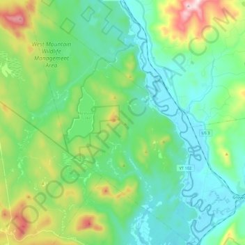
Name: Maidstone topographic map, elevation, terrain.
Location: Maidstone, Essex County, Vermont, 05905, United States (44.56899 -71.69976 44.72113 -71.53507)
Average elevation: 416 m
Minimum elevation: 251 m
Maximum elevation: 908 m
Thank you for supporting this site ❤️
Make a donation
Make a donation
Other topographic maps
Click on a map to view its topography, its elevation and its terrain.
Thank you for supporting this site ❤️
Make a donation
Make a donation
Concord Corner
United States > Vermont > Essex County > Concord > Concord Corner
Average elevation: 438 m