
Thank you for supporting this site ❤️
Make a donation
Make a donation
Męka-Jamy topographic map
Click on the map to display elevation.
Thank you for supporting this site ❤️
Make a donation
Make a donation
About this map
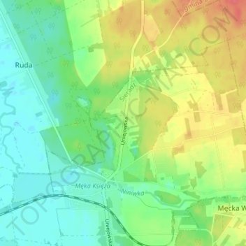
Name: Męka-Jamy topographic map, elevation, terrain.
Location: Męka-Jamy, Sieradz, Sieradz County, Łódź Voivodeship, Poland (51.60781 18.76619 51.64781 18.80619)
Average elevation: 147 m
Minimum elevation: 126 m
Maximum elevation: 179 m
Thank you for supporting this site ❤️
Make a donation
Make a donation
Other topographic maps
Click on a map to view its topography, its elevation and its terrain.