
Thank you for supporting this site ❤️
Make a donation
Make a donation
Wildhaus-Alt St. Johann topographic map
Click on the map to display elevation.
Thank you for supporting this site ❤️
Make a donation
Make a donation
About this map
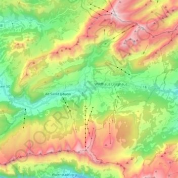
Name: Wildhaus-Alt St. Johann topographic map, elevation, terrain.
Average elevation: 1,453 m
Minimum elevation: 718 m
Maximum elevation: 2,479 m
Thank you for supporting this site ❤️
Make a donation
Make a donation
Other topographic maps
Click on a map to view its topography, its elevation and its terrain.
Wildhaus
Switzerland > St. Gallen > Wahlkreis Toggenburg > Wildhaus-Alt St. Johann
Average elevation: 1,244 m
Thank you for supporting this site ❤️
Make a donation
Make a donation
Riet
Switzerland > St. Gallen > Wahlkreis Toggenburg > Bütschwil-Ganterschwil > Bütschwil
Average elevation: 687 m