
Make a donation
Zahle topographic map
Click on the map to display elevation.
Make a donation
Zahle
Zahlé is located 55 km (34 mi) east of the capital Beirut, close to the Beirut-Damascus road, and lies at the junction of Mount Lebanon and the Beqaa Valley, at a mean elevation of 1,000 m. Established in the 18th century by Christians, Zahlé maintains its predominantly Greek Catholic character. The city has historically enjoyed convenient accessibility via road and rail, leveraging its strategic location as a trade hub.
Make a donation
About this map
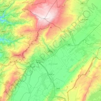
Name: Zahle topographic map, elevation, terrain.
Location: Zahle, Zahlé District, Beqaa Governorate, 1801, Lebanon (33.68771 35.74250 34.00771 36.06250)
Average elevation: 1,281 m
Minimum elevation: 562 m
Maximum elevation: 2,617 m
Make a donation
Other topographic maps
Click on a map to view its topography, its elevation and its terrain.
Make a donation
Shouf Cedar Biosphere Reserve Limit
Precipitation in the watershed is the source of both surface streamflow and groundwater. The major portion of this occurs as rain. Snowfall often occurs at the upper elevations but snow seldom persists more than a few days and disappears before the end of the rainy season. Normally snow has little overall…
Average elevation: 980 m
Make a donation