
Thank you for supporting this site ❤️
Make a donation
Make a donation
Bình Châu topographic map
Click on the map to display elevation.
Thank you for supporting this site ❤️
Make a donation
Make a donation
About this map
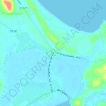
Name: Bình Châu topographic map, elevation, terrain.
Location: Bình Châu, Quảng Ngãi Province, Vietnam (15.21647 108.88636 15.25647 108.92636)
Average elevation: 8 m
Minimum elevation: -2 m
Maximum elevation: 65 m
Thank you for supporting this site ❤️
Make a donation
Make a donation
Other topographic maps
Click on a map to view its topography, its elevation and its terrain.
Thank you for supporting this site ❤️
Make a donation
Make a donation
Kon Tum
Kon Tum City is situated in the southern part of Kon Tum Province, within a basin landscape at an elevation of approximately 525 meters above sea level. It is encircled by the Dak Bla River valley. The city is located 547 kilometers north of Ho Chi Minh City, 292 kilometers south of Da Nang, and 1,087…
Average elevation: 609 m
Thank you for supporting this site ❤️
Make a donation
Make a donation