
Thank you for supporting this site ❤️
Make a donation
Make a donation
South Kesteven topographic map
Click on the map to display elevation.
Thank you for supporting this site ❤️
Make a donation
Make a donation
About this map
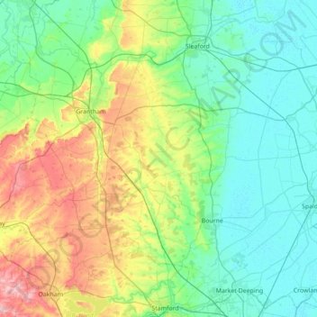
Name: South Kesteven topographic map, elevation, terrain.
Location: South Kesteven, Lincolnshire, England, United Kingdom (52.64022 -0.80432 53.05995 -0.21251)
Average elevation: 53 m
Minimum elevation: -1 m
Maximum elevation: 218 m
Thank you for supporting this site ❤️
Make a donation
Make a donation
Other topographic maps
Click on a map to view its topography, its elevation and its terrain.
Fleet Hargate
United Kingdom > England > Lincolnshire > South Holland > Fleet Hargate
Average elevation: 3 m