
Make a donation
Saarland topographic map
Click on the map to display elevation.
Make a donation
About this map
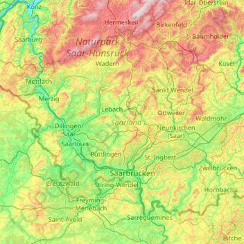
Name: Saarland topographic map, elevation, terrain.
Location: Saarland, Germany (49.11195 6.35579 49.63943 7.40483)
Average elevation: 325 m
Minimum elevation: 131 m
Maximum elevation: 761 m
Make a donation
Other topographic maps
Click on a map to view its topography, its elevation and its terrain.
Börnersdorf
Germany > Saxony > Sächsische Schweiz-Osterzgebirge > Bad Gottleuba-Berggießhübel
Average elevation: 494 m
Make a donation
Allgäu
The alpine regions of the Allgäu rise over 2,000 metres in elevation and are popular for winter skiing. The Allgovian area is notable for its beautiful landscapes and is popular for vacations and therapeutic stays. It is well known in Germany for its farm produce, especially dairy products including…
Average elevation: 1,087 m
Make a donation
Jena
Germany > Thuringia > Jena > Jena
Jena is situated in a hilly landscape in eastern Thuringia at the Saale river, between the Harz mountains 85 km (53 mi) in the north, the Thuringian Forest/Thuringian Highland 50 km (31 mi) in the southwest and the Ore Mountains, 75 km (47 mi) in the southeast. The municipal terrain is hilly with rugged slopes…
Average elevation: 289 m
Make a donation