
Make a donation
Sakha Republic topographic map
Click on the map to display elevation.
Make a donation
About this map
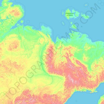
Name: Sakha Republic topographic map, elevation, terrain.
Location: Sakha Republic, Far Eastern Federal District, Russia (55.48767 105.50834 77.31023 163.10598)
Average elevation: 281 m
Minimum elevation: -3 m
Maximum elevation: 2,737 m
Make a donation
Other topographic maps
Click on a map to view its topography, its elevation and its terrain.
Central Caucasian Ridge
Russia > Kabardino-Balkaria > Cherek District > Verkhnya Balkariya
The highest and rockiest section of the range is located in its central part. Although not as high as the topmost summits of the Lateral Range to the north, the highest elevations of the Main Caucasian Range include the 5,193 meters (17,037 ft) high Shkhara, the 4,466 meters (14,652 ft) high Mount Bazardüzü…
Average elevation: 2,784 m
Make a donation
Make a donation
Make a donation
Make a donation
Ural Mountains
Russia > Khanty-Mansiysk Autonomous Okrug – Ugra > Beryozovsky District
As attested by Sigismund von Herberstein, in the 16th century Russians called the Ural range by a variety of names derived from the Russian words for rock (stone) and belt. The modern Russian name for the Urals (Урал, Ural), first appearing in the 16th–17th century during the Russian conquest of Siberia,…
Average elevation: 1,435 m
Make a donation
Make a donation