
Thank you for supporting this site ❤️
Make a donation
Make a donation
Läppe topographic map
Click on the map to display elevation.
Thank you for supporting this site ❤️
Make a donation
Make a donation
About this map
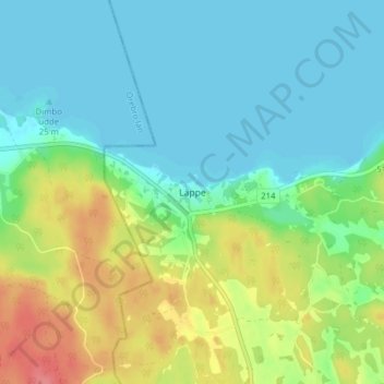
Name: Läppe topographic map, elevation, terrain.
Location: Läppe, Vingåkers kommun, Södermanlands län, Zweden (59.11214 15.78572 59.15214 15.82572)
Average elevation: 43 m
Minimum elevation: 22 m
Maximum elevation: 90 m
Thank you for supporting this site ❤️
Make a donation
Make a donation
Other topographic maps
Click on a map to view its topography, its elevation and its terrain.