
Make a donation
Zwardoń topographic map
Click on the map to display elevation.
Make a donation
Zwardoń
Zwardoń, located at the elevation of 690 meters above sea level, is placed between three mountain passes - Przysłop, Zwardońska and Graniczne. Until 1975, the village was administratively tied with Kraków and Lesser Poland. In 1975 - 1999, it belonged to Bielsko-Biala Voivodeship, and after the territorial reform of Poland in 1999, it became part of the Silesian Voivodeship, even though historically it does not belong to Silesia. Zwardoń has a rail station along the historic Galician Transversal Railway, which connects Żywiec and other Polish cities with Slovak town of Žilina, and further on, Vienna. Since the construction of the line, Zwardoń has been a border station, and the crossing was closed down in 2007, due to Schengen Agreement. The village is also located on the Expressway S69, which goes from Bielsko-Biała to Slovakia.
Make a donation
About this map
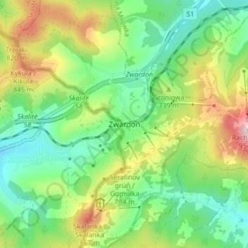
Name: Zwardoń topographic map, elevation, terrain.
Average elevation: 710 m
Minimum elevation: 585 m
Maximum elevation: 941 m
Make a donation
Other topographic maps
Click on a map to view its topography, its elevation and its terrain.