
Make a donation
Community of Madrid topographic map
Click on the map to display elevation.
Make a donation
Community of Madrid
Most of province lies between 600 and 1,000 m above sea level. However, there the altitude ranges from the 2,428 metres of Peñalara and the 430 metres of the Alberche river when it leaves Villa del Prado into the province of Toledo. Other considerable heights, as well as being famous, are the Bola del Mundo ("Ball of the World") in Navacerrada, at a height of 2,258 m, the Siete Picos ("Seven Peaks") in Cercedilla, at 2,138 m, and the Peña Cebollera (2,129 m) at the northernmost end of the province, a tripoint between the Madrid region and the provinces of Segovia and Guadalajara.
Make a donation
About this map
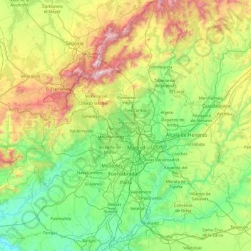
Name: Community of Madrid topographic map, elevation, terrain.
Location: Community of Madrid, Spain (39.88463 -4.57901 41.16574 -3.05299)
Average elevation: 852 m
Minimum elevation: 385 m
Maximum elevation: 2,404 m
Make a donation
Other topographic maps
Click on a map to view its topography, its elevation and its terrain.
Pyrenees
The Pyrenees are a mountain range straddling the border of France and Spain. They extend nearly 500 km (310 mi) from their union with the Cantabrian Mountains to Cap de Creus on the Mediterranean coast, reaching a maximum altitude of 3,404 metres (11,168 ft) at the peak of Aneto.
Average elevation: 491 m
Make a donation
Make a donation
Make a donation
Make a donation
Isla Nueva
Spain > Valencian Community > el Baix Segura / La Vega Baja del Segura > Benferri
Average elevation: 93 m
Make a donation
Make a donation
Make a donation
Make a donation
Salas de Los Barrios
Spain > Castile and León > El Bierzo > Ponferrada > Salas de Los Barrios
Average elevation: 724 m
Make a donation