
Thank you for supporting this site ❤️
Make a donation
Make a donation
Béthanie topographic map
Click on the map to display elevation.
Thank you for supporting this site ❤️
Make a donation
Make a donation
About this map
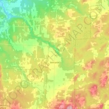
Name: Béthanie topographic map, elevation, terrain.
Location: Béthanie, Acton, Montérégie, Québec, Canada (45.44920 -72.45440 45.57325 -72.39946)
Average elevation: 192 m
Minimum elevation: 101 m
Maximum elevation: 303 m
Thank you for supporting this site ❤️
Make a donation
Make a donation
Other topographic maps
Click on a map to view its topography, its elevation and its terrain.