
Make a donation
Łódź topographic map
Click on the map to display elevation.
Make a donation
Łódź
Łódź covers an area of approximately 293 square kilometres (113 sq mi) and is located in the centre of Poland. The city lies in the lowlands of the Central European Plain, not exceeding 300 metres in elevation. Topographically, the Łódź region is generally characterised by a flat landscape, with only several highlands which do not exceed 50 metres above the terrain level. The soil is predominantly sandy (62%) followed by clay (24%), silt (8%), and organogenic formations (6%) from regional wetlands. The forest cover (equivalent to 4.2% of the whole country) is considerably low compared to other cities, regions, and provinces of Poland.
Make a donation
About this map
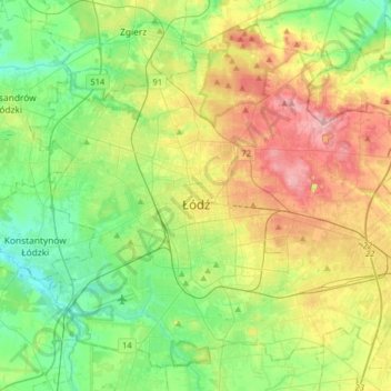
Name: Łódź topographic map, elevation, terrain.
Location: Łódź, Łódź Voivodeship, Poland (51.68614 19.32086 51.85983 19.63995)
Average elevation: 203 m
Minimum elevation: 158 m
Maximum elevation: 281 m
Make a donation
Other topographic maps
Click on a map to view its topography, its elevation and its terrain.
Make a donation
Make a donation
Make a donation
Make a donation
Make a donation
Make a donation
Make a donation
Make a donation
Borki Lipkowskie
Poland > Łódź Voivodeship > Poddębice County > Borki Lipkowskie
Average elevation: 141 m
Make a donation
Wieruszów
Poland > Łódź Voivodeship > Wieruszów County > Wieruszów > Wieruszów
Average elevation: 163 m
Make a donation