
Thank you for supporting this site ❤️
Make a donation
Make a donation
Kristianstads kommun topographic map
Click on the map to display elevation.
Thank you for supporting this site ❤️
Make a donation
Make a donation
About this map
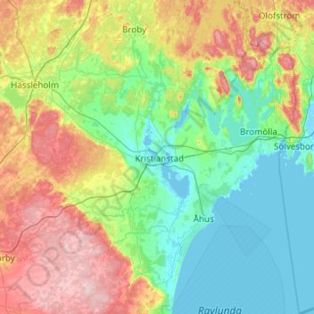
Name: Kristianstads kommun topographic map, elevation, terrain.
Location: Kristianstads kommun, Skåne County, Sweden (55.75500 13.74760 56.30496 14.59533)
Average elevation: 57 m
Minimum elevation: -5 m
Maximum elevation: 204 m
Thank you for supporting this site ❤️
Make a donation
Make a donation
Other topographic maps
Click on a map to view its topography, its elevation and its terrain.