
Thank you for supporting this site ❤️
Make a donation
Make a donation
Hunter Mountain topographic map
Click on the map to display elevation.
Thank you for supporting this site ❤️
Make a donation
Make a donation
About this map
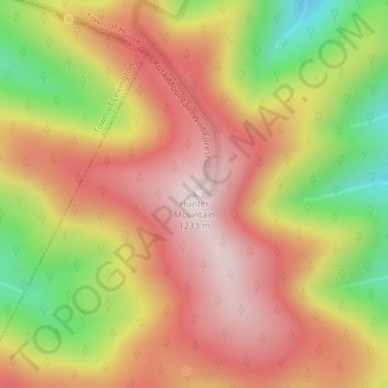
Name: Hunter Mountain topographic map, elevation, terrain.
Average elevation: 1,004 m
Minimum elevation: 696 m
Maximum elevation: 1,226 m
Thank you for supporting this site ❤️
Make a donation
Make a donation
Other topographic maps
Click on a map to view its topography, its elevation and its terrain.
Haines Falls
United States > New York > Greene County > Town of Hunter > Haines Falls
Average elevation: 627 m
Platte Clove
United States > New York > Greene County > Town of Hunter > Platte Clove Bruderhof
Average elevation: 575 m