
Make a donation
La Marsa topographic map
Click on the map to display elevation.
Make a donation
About this map
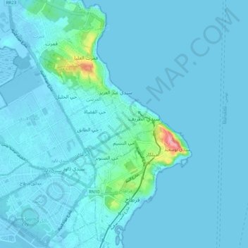
Name: La Marsa topographic map, elevation, terrain.
Location: La Marsa, Tunis, 2070, Tunisia (36.83909 10.28768 36.91909 10.36768)
Average elevation: 8 m
Minimum elevation: -6 m
Maximum elevation: 123 m
Make a donation
Other topographic maps
Click on a map to view its topography, its elevation and its terrain.
Tunis
The city of Tunis is built on a hill slope down to the lake of Tunis. These hills contain places such as Notre-Dame de Tunis, Ras Tabia, La Rabta, La Kasbah, Montfleury, and La Manoubia with altitudes just above 50 metres (160 feet). The city is located at the crossroads of a narrow strip of land between Lake…
Average elevation: 37 m
Make a donation
Tunis
The city of Tunis is built on a hill slope down to the lake of Tunis. These hills contain places such as Notre-Dame de Tunis, Ras Tabia, La Rabta, La Kasbah, Montfleury, and La Manoubia with altitudes just above 50 metres (160 feet). The city is located at the crossroads of a narrow strip of land between Lake…
Average elevation: 37 m
Make a donation
Tunis
The city of Tunis is built on a hill slope down to the lake of Tunis. These hills contain places such as Notre-Dame de Tunis, Ras Tabia, La Rabta, La Kasbah, Montfleury, and La Manoubia with altitudes just above 50 metres (160 feet). The city is located at the crossroads of a narrow strip of land between Lake…
Average elevation: 37 m
Tunis
The city of Tunis is built on a hill slope down to the lake of Tunis. These hills contain places such as Notre-Dame de Tunis, Ras Tabia, La Rabta, La Kasbah, Montfleury, and La Manoubia with altitudes just above 50 metres (160 feet). The city is located at the crossroads of a narrow strip of land between Lake…
Average elevation: 37 m
Medina of Tunis
In the case of domestic architecture, the more a building is set back from the shops, the more it is valued. The concept of withdrawal and privacy is paramount. The late introduction of a sewer system means that much waste water still flows through the streets of the Medina. The largest houses and noble places…
Average elevation: 16 m
Make a donation