
Thank you for supporting this site ❤️
Make a donation
Make a donation
Serra da Vila topographic map
Click on the map to display elevation.
Thank you for supporting this site ❤️
Make a donation
Make a donation
About this map
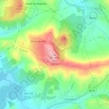
Name: Serra da Vila topographic map, elevation, terrain.
Location: Serra da Vila, Torres Vedras, Lisbon, 2560-581, Portugal (39.06358 -9.26593 39.06368 -9.26583)
Average elevation: 93 m
Minimum elevation: 27 m
Maximum elevation: 207 m
Thank you for supporting this site ❤️
Make a donation
Make a donation
Other topographic maps
Click on a map to view its topography, its elevation and its terrain.