
Thank you for supporting this site ❤️
Make a donation
Make a donation
Gampaha District topographic map
Click on the map to display elevation.
Thank you for supporting this site ❤️
Make a donation
Make a donation
About this map
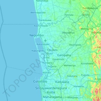
Name: Gampaha District topographic map, elevation, terrain.
Location: Gampaha District, Western Province, Sri Lanka (6.90706 79.61616 7.33053 80.21268)
Average elevation: 25 m
Minimum elevation: 0 m
Maximum elevation: 425 m
Thank you for supporting this site ❤️
Make a donation
Make a donation
Other topographic maps
Click on a map to view its topography, its elevation and its terrain.
Thank you for supporting this site ❤️
Make a donation
Make a donation
Baduraliya
Sri Lanka > Western Province > Palinda-Nuwara (Baduraliya) DS Division
Baduraliya (Sinhala: බදුරලිය) is a town in the Kalutara District in Sri Lanka. It is approximately 82 km (51 mi) from Colombo and 58 km (36 mi) from Rathnapura. Baduraliya was named after a rally against taxes. "Badu" in Sinhala means taxes and “raliya” means a rally. Baduraliya is surrounded…
Average elevation: 67 m
Thank you for supporting this site ❤️
Make a donation
Make a donation