
Make a donation
Tías topographic map
Click on the map to display elevation.
Make a donation
About this map
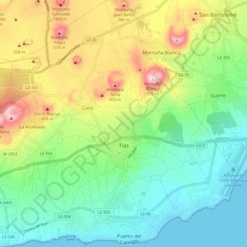
Name: Tías topographic map, elevation, terrain.
Location: Tías, Las Palmas, Canary Islands, Spain (28.91767 -13.70701 29.00682 -13.60499)
Average elevation: 196 m
Minimum elevation: -1 m
Maximum elevation: 581 m
Make a donation
Other topographic maps
Click on a map to view its topography, its elevation and its terrain.
Make a donation
Make a donation
Parque de la Puerta de Tierra
Spain > Canary Islands > San Juan del Reparo (La Culata) > San Pedro de Daute
Average elevation: 182 m
Make a donation
Make a donation
Masca
Spain > Canary Islands > Buenavista del Norte
Masca is a small mountain village on the island of Tenerife. It was originally a Guanche settlement before the Spanish conquest in 1496. The village is now home to around 90 inhabitants. The village lies at an altitude of 650 m in the Macizo de Teno mountains, which extend up to the northwesternmost point of…
Average elevation: 769 m
Make a donation
Make a donation
Make a donation
Make a donation