
Make a donation
Isla San Jose topographic map
Click on the map to display elevation.
Make a donation
About this map
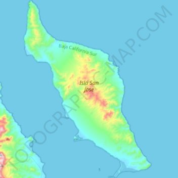
Name: Isla San Jose topographic map, elevation, terrain.
Average elevation: 60 m
Minimum elevation: -1 m
Maximum elevation: 882 m
Make a donation
Other topographic maps
Click on a map to view its topography, its elevation and its terrain.
La Paz
Mexico > Baja California Sur > Municipio de La Paz
La Paz is located on the Baja California peninsula on the Bay of La Paz, 210 kilometres (130 mi) south of Ciudad Constitución, municipality of Comondú, and 202 kilometres (126 mi) north of Cabo San Lucas, municipality of Los Cabos. It is located 81 kilometres (50 mi) north of the town of Todos Santos. Its…
Average elevation: 114 m
Make a donation
La Paz
Mexico > Baja California Sur > Municipio de La Paz
La Paz is located on the Baja California peninsula on the Bay of La Paz, 210 kilometres (130 mi) south of Ciudad Constitución, municipality of Comondú, and 202 kilometres (126 mi) north of Cabo San Lucas, municipality of Los Cabos. It is located 81 kilometres (50 mi) north of the town of Todos Santos. Its…
Average elevation: 114 m
La Paz
Mexico > Baja California Sur > Municipio de La Paz
The city, in west-central Bolivia 68 km (42 mi) southeast of Lake Titicaca, is set in a canyon created by the Choqueyapu River. It is in a bowl-like depression, part of the Amazon basin, surrounded by the high mountains of the Altiplano. Overlooking the city is the towering, triple-peaked Illimani. Its peaks…
Average elevation: 114 m
Make a donation