
Thank you for supporting this site ❤️
Make a donation
Make a donation
Ciudad López Mateos topographic map
Click on the map to display elevation.
Thank you for supporting this site ❤️
Make a donation
Make a donation
Ciudad López Mateos
Its main elevations are Biznaga Hill, Atlaco Hill La Condesa Hill and Grande Hill.
Thank you for supporting this site ❤️
Make a donation
Make a donation
About this map
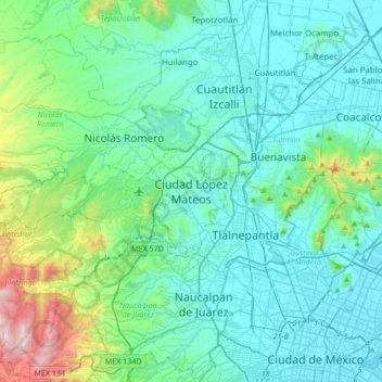
Name: Ciudad López Mateos topographic map, elevation, terrain.
Average elevation: 2,426 m
Minimum elevation: 2,222 m
Maximum elevation: 3,514 m
Thank you for supporting this site ❤️
Make a donation
Make a donation