
Thank you for supporting this site ❤️
Make a donation
Make a donation
Wennigsen (Deister) topographic map
Click on the map to display elevation.
Thank you for supporting this site ❤️
Make a donation
Make a donation
Wennigsen (Deister)
Wennigsen borders on (from north and clockwise) Gehrden, Ronnenberg, Springe and Barsinghausen. The highest elevation is the Bröhn, the highest hill of the Deister with 405 meters.
Thank you for supporting this site ❤️
Make a donation
Make a donation
About this map
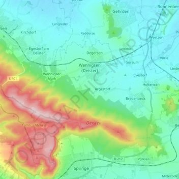
Name: Wennigsen (Deister) topographic map, elevation, terrain.
Average elevation: 145 m
Minimum elevation: 59 m
Maximum elevation: 403 m
Thank you for supporting this site ❤️
Make a donation
Make a donation
Other topographic maps
Click on a map to view its topography, its elevation and its terrain.
Roderbruch
Germany > Lower Saxony > Region Hannover > Neustadt am Rübenberge > Dudensen
Average elevation: 48 m