
Thank you for supporting this site ❤️
Make a donation
Make a donation
Prétérit topographic map
Click on the map to display elevation.
Thank you for supporting this site ❤️
Make a donation
Make a donation
About this map
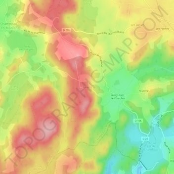
Name: Prétérit topographic map, elevation, terrain.
Average elevation: 572 m
Minimum elevation: 492 m
Maximum elevation: 640 m
Thank you for supporting this site ❤️
Make a donation
Make a donation
Other topographic maps
Click on a map to view its topography, its elevation and its terrain.
Étang Lamier
France > Bourgogne-Franche-Comté > Côte-d'Or > Champeau-en-Morvan
Average elevation: 581 m