
Thank you for supporting this site ❤️
Make a donation
Make a donation
Navarre topographic map
Click on the map to display elevation.
Thank you for supporting this site ❤️
Make a donation
Make a donation
Navarre
Despite its relatively small size, Navarre features stark contrasts in geography, from the Pyrenees mountain range that dominates the territory to the plains of the Ebro river valley in the south. The highest point in Navarre is Mesa de los Tres Reyes, with an elevation of 2,428 metres (7,965 feet).
Thank you for supporting this site ❤️
Make a donation
Make a donation
About this map
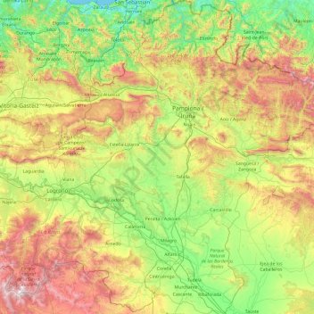
Name: Navarre topographic map, elevation, terrain.
Location: Navarre, Spain (41.90989 -2.49994 43.31495 -0.72334)
Average elevation: 629 m
Minimum elevation: -1 m
Maximum elevation: 2,144 m
Thank you for supporting this site ❤️
Make a donation
Make a donation
Other topographic maps
Click on a map to view its topography, its elevation and its terrain.
Thank you for supporting this site ❤️
Make a donation
Make a donation
Thank you for supporting this site ❤️
Make a donation
Make a donation
Thank you for supporting this site ❤️
Make a donation
Make a donation
Thank you for supporting this site ❤️
Make a donation
Make a donation