
Thank you for supporting this site ❤️
Make a donation
Make a donation
Isières topographic map
Click on the map to display elevation.
Thank you for supporting this site ❤️
Make a donation
Make a donation
About this map
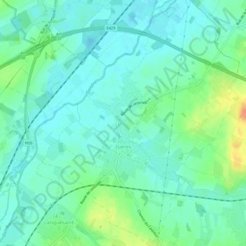
Name: Isières topographic map, elevation, terrain.
Location: Isières, Ath, Hainaut, Wallonie, Belgique (50.65018 3.79307 50.68381 3.84322)
Average elevation: 31 m
Minimum elevation: 19 m
Maximum elevation: 62 m
Thank you for supporting this site ❤️
Make a donation
Make a donation
Other topographic maps
Click on a map to view its topography, its elevation and its terrain.