
Make a donation
Kota Bekasi topographic map
Click on the map to display elevation.
Make a donation
Kota Bekasi
The City of Bekasi is a part of the Bekasi river basin, located in the downstream area of the basin with slopes ranging from 0 to 2% and elevations between 11 meters to 81 meters above sea level. The city of Bekasi is part of the Bekasi river basin and is located in the downstream area of the basin, with a slope ranging from 0 to 2% and elevations between 11 meters to 81 meters above sea level. This topographical condition leads to frequent flooding in many areas of Bekasi, especially during the rainy season, such as in the districts of Jatiasih, East Bekasi, Rawalumbu, South Bekasi, West Bekasi, and Pondok Melati.
Make a donation
About this map
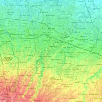
Name: Kota Bekasi topographic map, elevation, terrain.
Location: Kota Bekasi, West Java, Java, Indonesia (-6.39860 106.89773 -6.17177 107.04238)
Average elevation: 32 m
Minimum elevation: -1 m
Maximum elevation: 91 m
Make a donation
Other topographic maps
Click on a map to view its topography, its elevation and its terrain.
Bandung
Indonesia > West Java > Bandung
Bandung, the capital of West Java province, located about 180 kilometres (110 mi) southeast of Jakarta, is the third-largest city in Indonesia. Its elevation is 768 metres (2,520 ft) above sea level and is surrounded by up to 2,400 metres (7,900 feet) high Late Tertiary and Quaternary volcanic terrain. The 400…
Average elevation: 879 m
Make a donation
Bogor
The city is situated in the western part of Java island, about 53 km south of the capital Jakarta and 85 km northwest of Bandung, the administrative center of West Java Province. Bogor spreads over a basin near volcanoes Salak, which peaks at about 12 km south, and Mount Gede whose top is 22–25 km south-east…
Average elevation: 442 m
Make a donation
Make a donation
Make a donation