
Thank you for supporting this site ❤️
Make a donation
Make a donation
Huixquilucan topographic map
Click on the map to display elevation.
Thank you for supporting this site ❤️
Make a donation
Make a donation
About this map
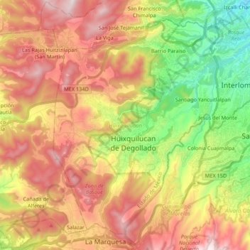
Name: Huixquilucan topographic map, elevation, terrain.
Location: Huixquilucan, State of Mexico, Mexico (19.30333 -99.40418 19.43891 -99.23962)
Average elevation: 2,921 m
Minimum elevation: 2,341 m
Maximum elevation: 3,508 m
Thank you for supporting this site ❤️
Make a donation
Make a donation
Other topographic maps
Click on a map to view its topography, its elevation and its terrain.