
Thank you for supporting this site ❤️
Make a donation
Make a donation
Jägerhof topographic map
Click on the map to display elevation.
Thank you for supporting this site ❤️
Make a donation
Make a donation
About this map
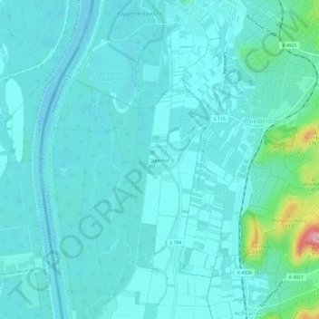
Name: Jägerhof topographic map, elevation, terrain.
Average elevation: 192 m
Minimum elevation: 171 m
Maximum elevation: 330 m
Thank you for supporting this site ❤️
Make a donation
Make a donation
Other topographic maps
Click on a map to view its topography, its elevation and its terrain.
Niederrimsingen
Deutschland > Baden-Württemberg > Landkreis Breisgau-Hochschwarzwald > Breisach am Rhein
Average elevation: 214 m
Breisach (Kernstadt)
Deutschland > Baden-Württemberg > Landkreis Breisgau-Hochschwarzwald > Breisach am Rhein > Hochstetten
Average elevation: 212 m